Where does Dragoon get its drinking water?
The Dragoon Water Company itself calls it's source for water the "Dragoon Aquifer" in their annual water quality reports — two wells drawing from it within the local alluvial aquifer, which is a small part of the much larger Willcox Groundwater Basin aka WGB. The "Dragoon Aquifer" is a mountain-front recharge zone along the Dragoon Mountains.
Specific micro-scale maps of our local alluvial aquifer are near impossible to find because it's not officially delineated as a separate basin by ADWR or USGS because it is classified as part of the WGB.
How will the copper mine expansion affect our water?
No one knows. Will Gunnison Copper always follow industry best practices? Will Gunnison Copper never have an EPA fine or have a contamination event that affects groundwater? Will Gunnison always be able to contain chemical drift from acid leaching or heavy metal contamination drift that is common to open pit copper mining? What about their proprietary Nuton microbes being used commercially for the first time anywhere in the entire mining industry? The say publicly that the microbes pose no human threat. Can they guarantee that? Where is the safety data? Can it become airborne aka aerosolize? What happens to human lungs that breath aerosolized microbes, acid or heavy metals?
What seems to be certain, the mines southern expansion does encroach on Dragoons water source.
Groundwater Flow
Generally, groundwater flows similar to surface water, but not always.
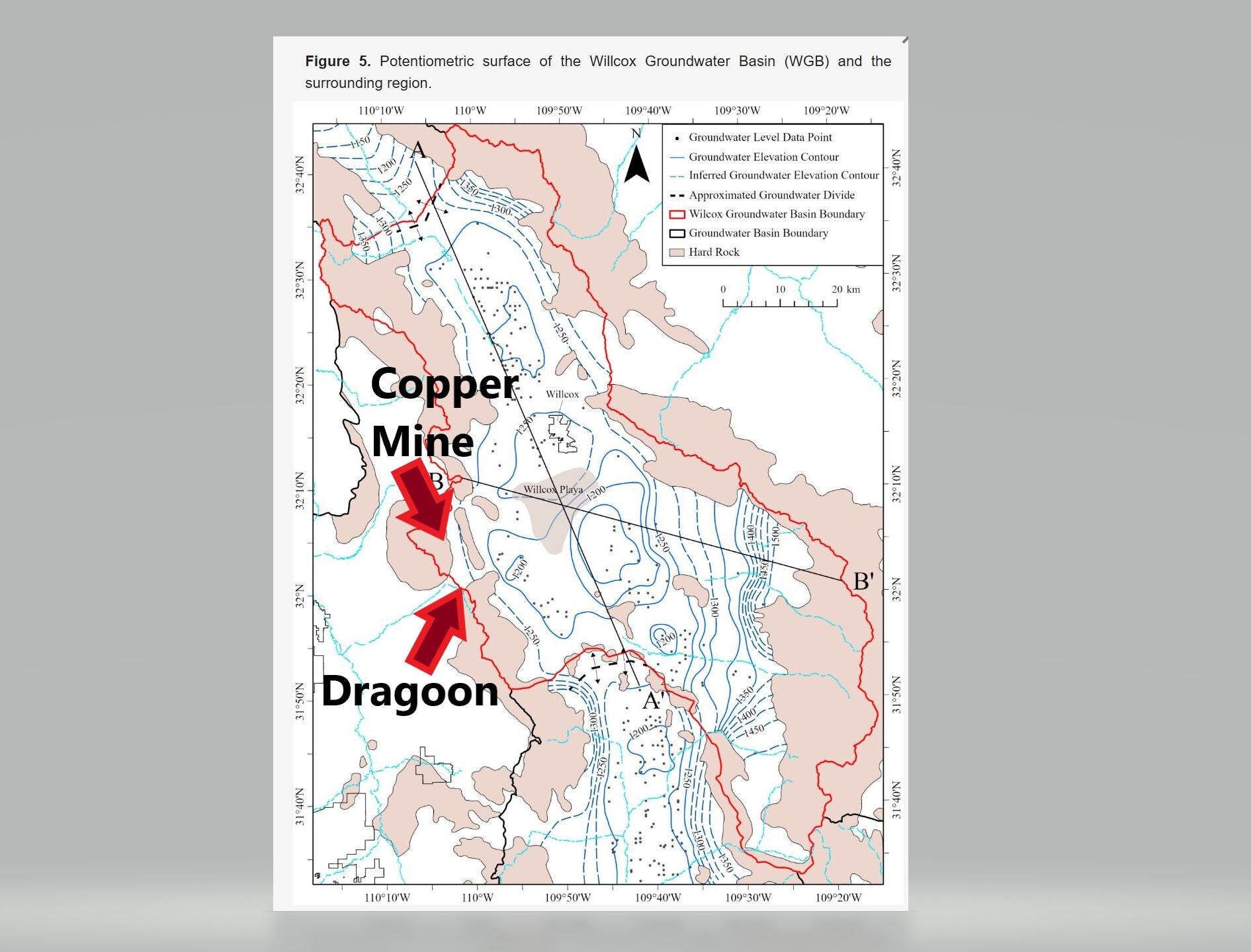
This chart to the right show the elevation contour of our groundwater. It flows "downhill" or down gradient.
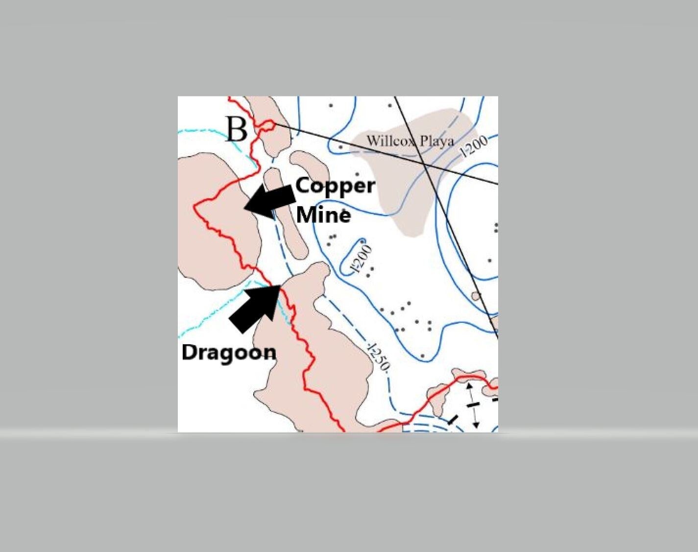
The chart to the right is from the below referenced publication.

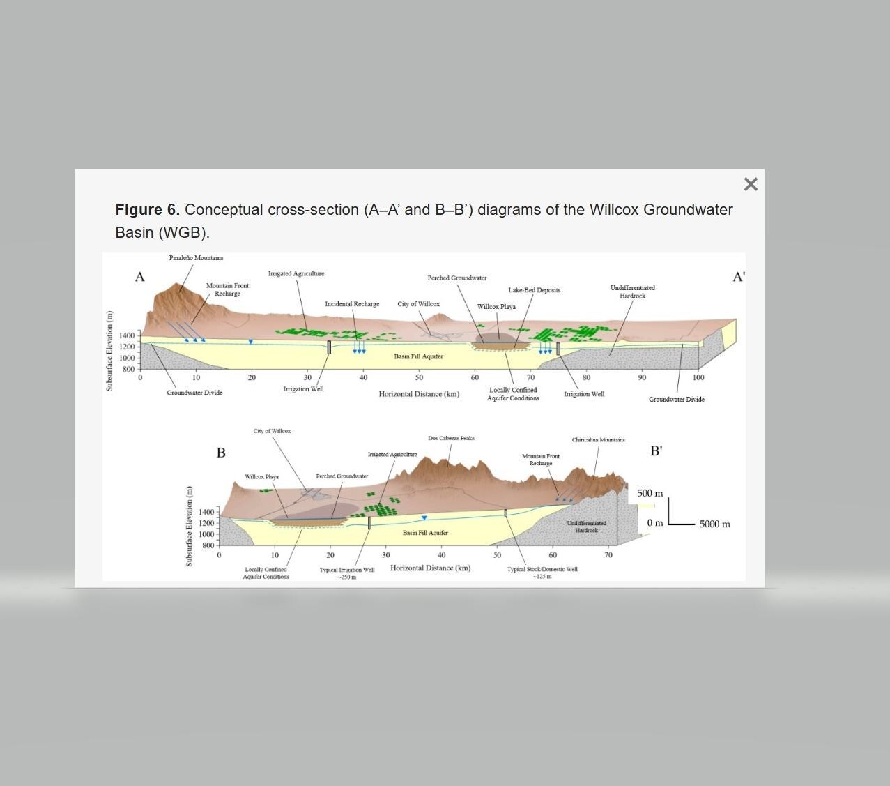
WGB cross-section, from the above chart. Match line A or B from the above to the left illustration.
The "Dragoon Aquifer" is a mountain-front recharge zone along the Dragoon Mountains. One can see how a mountain-front recharge zone works as illustrated by this diagram. Chart source below.
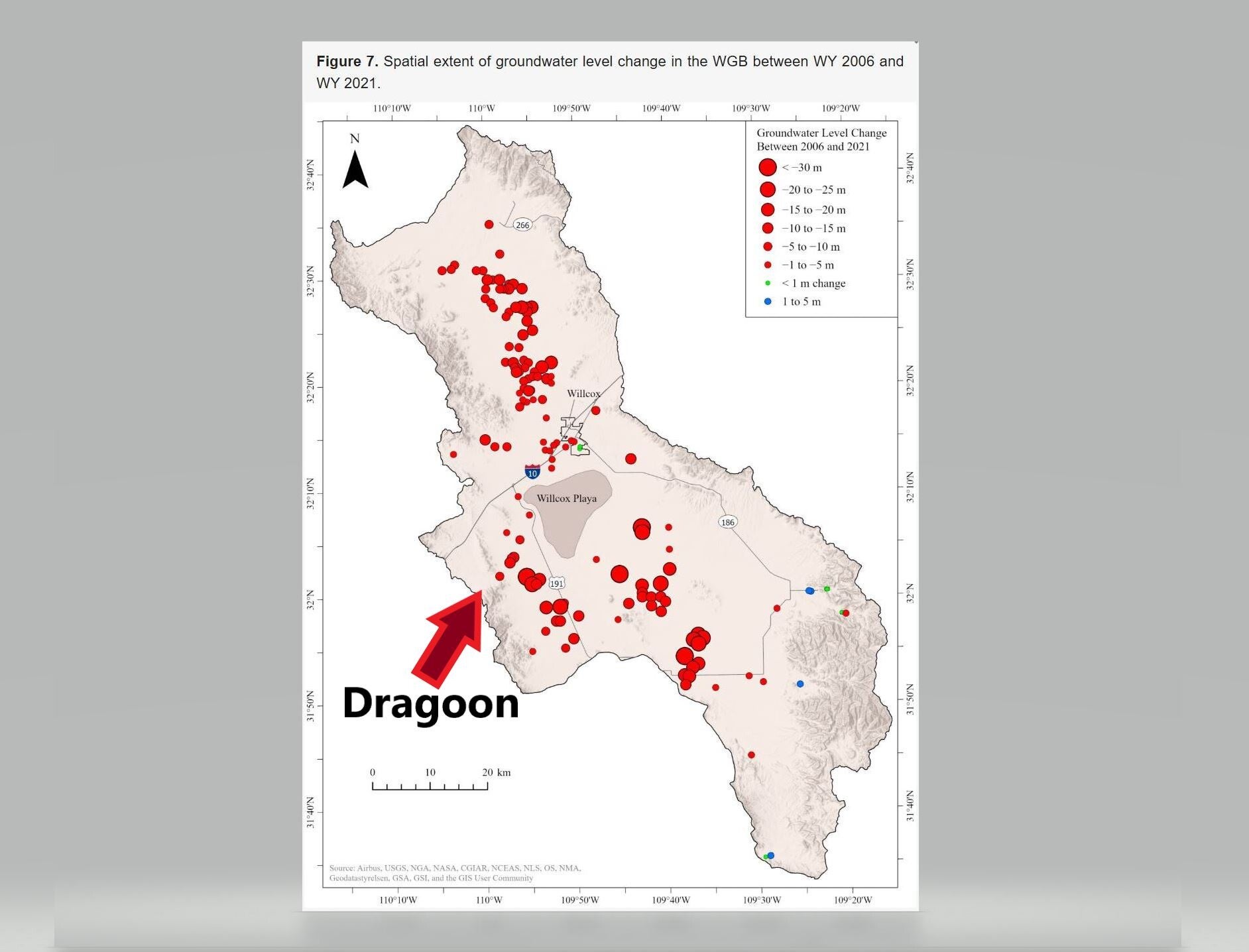
The WGB is deepening.
The groundwater sinking accelerates the flow from higher to lower areas as water generally runs "downhill". That should act to protect the Dragoon aquifer, unless it reaches such a point that it starts to drain it. Also, if Dragoon aquifer becomes lower than the area by the mine, then any groundwater issues the mine has caused could theoretically flow to Dragoon's wells in the Dragoon aquifer.
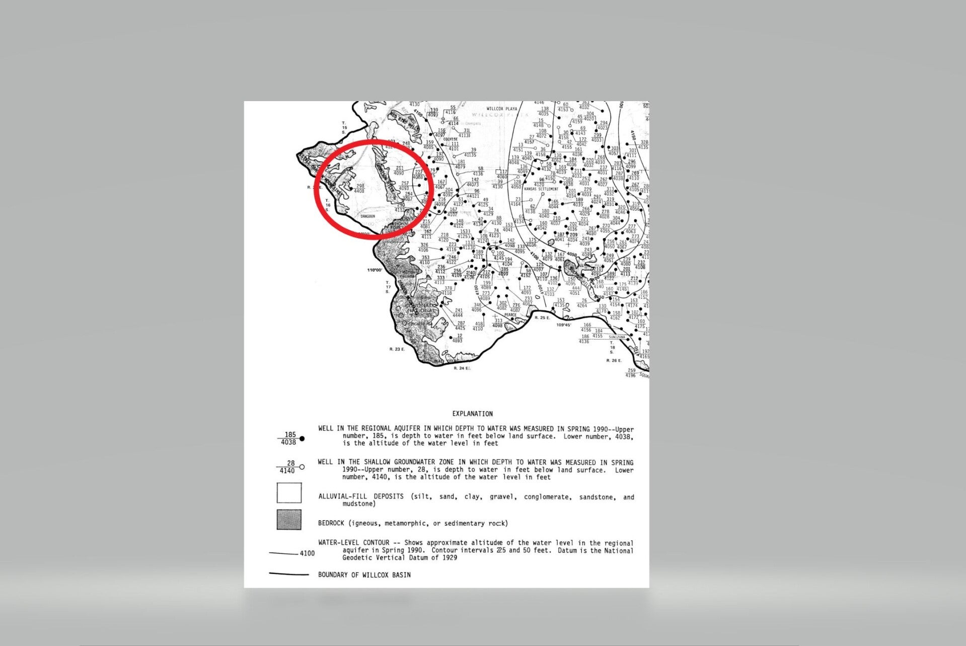
The chart to the right is from the publication below:

Groundwater contour close-up
It would appear that the copper mine is about the same "height" as the Dragoon wells. It's important to note that it also appears that the mine is located in the same aquifer as Dragoon's wells. If the southern most heap leach bed shown in the mine expansion illustration is in fact a leach bed, it could be considered dangerously close if there were a groundwater contamination event at that location!
The chart to the left is from the publication below:
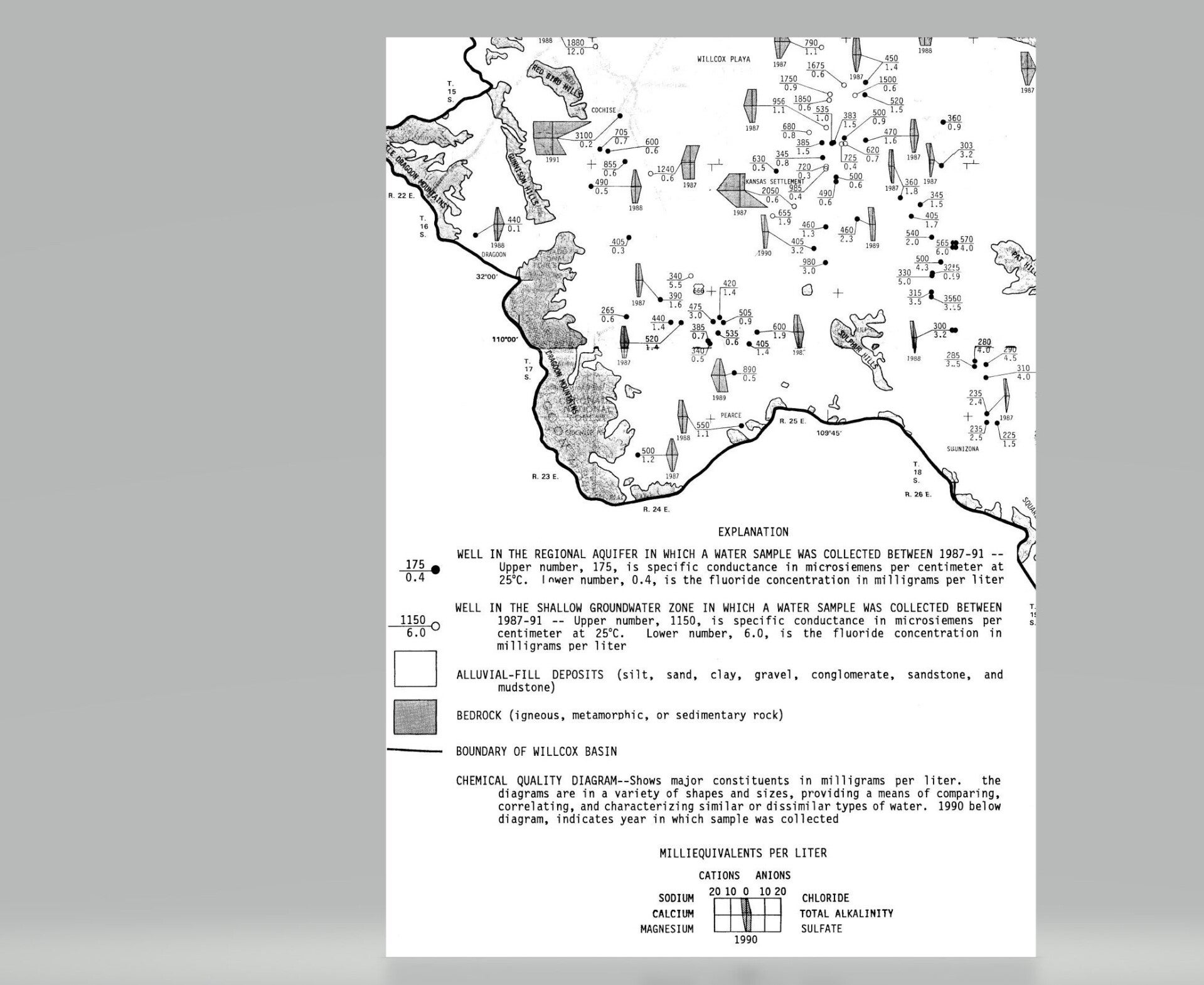
"Dragoon Aquifer" = Alluvial-Fill
The chart to the right shows the area of Dragoon and thus our well fields are in an Alluvial-fill deposit.
For us non-geologists, what that means is at the mountains degrade, erode or "melt" over millions of years, the valleys get filled in with the gravel created by the mountains disintegration. Typically, that gravel holds water rather nicely as is the case with our Dragoon Aquifer.
Unfortunately, this map also shows we share the same gravel with the Gunnison, Johnson Camp and Strong & Harris copper mines.
That means if the copper mines do not follow best practices OR simply make a mistake, the common gravel deposit could allow contaminants reach into the groundwater held by the commonly shared alluvial-fill water holding gravel.
The chart to the right is from a USGS publication found at Arizona Groundwater Explorer found here: https://rconnect.usgs.gov/az-agex/
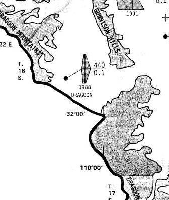
Dragoon Aquifer's water composition
The chart to the left shows a test sample of our water from 1988 with a microsiemens conductance per centimeter of 440 and a fluoride concentration of .1 milligrams per liter. It also shows relative alkalinity and dissolved solids concentrations.
The chart to the left and blow-up below is from a USGS publication found at Arizona Groundwater Explorer found here: https://rconnect.usgs.gov/az-agex/
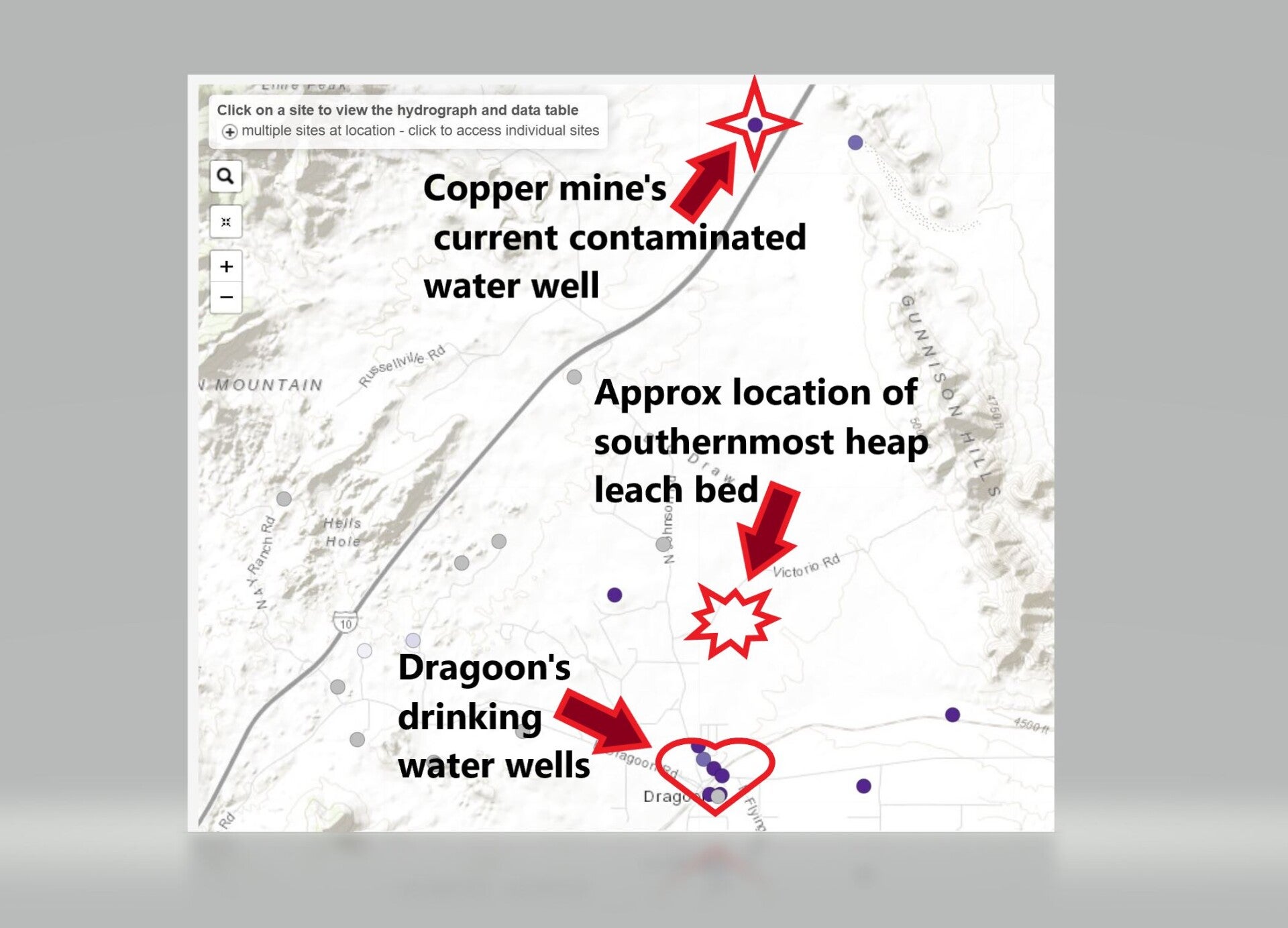
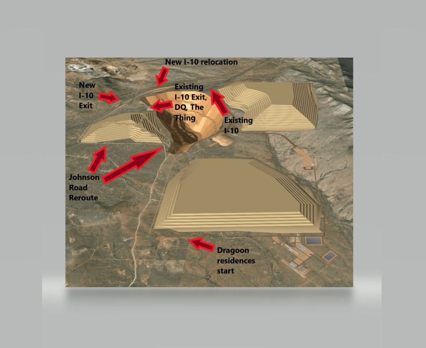
Acid or microbe leach bed less than 5,700 feet from Dragoons wells?
The image to the right show approximate locations of items being discussed on this page.
And yes, you read that correctly, the Johnson Camp Mine well is contaminated. They can only use it to flush toilets NOT handwashing or drinking as it is contaminated. They buy bottled water for employees.
It is noteworthy as illustrated above, Dragoon's water source is in the same aquifer as their contaminated well. It appears currently the water from their well flows down gradient toward the playa. Could that ever change?
Their southernmost heap leach bed appears to be less than 5.700 feet from the village of Dragoon's well field.
The image to the right is from Arizona Groundwater Explorer found here: https://rconnect.usgs.gov/az-agex/ Labels added by DragoonArizona.com
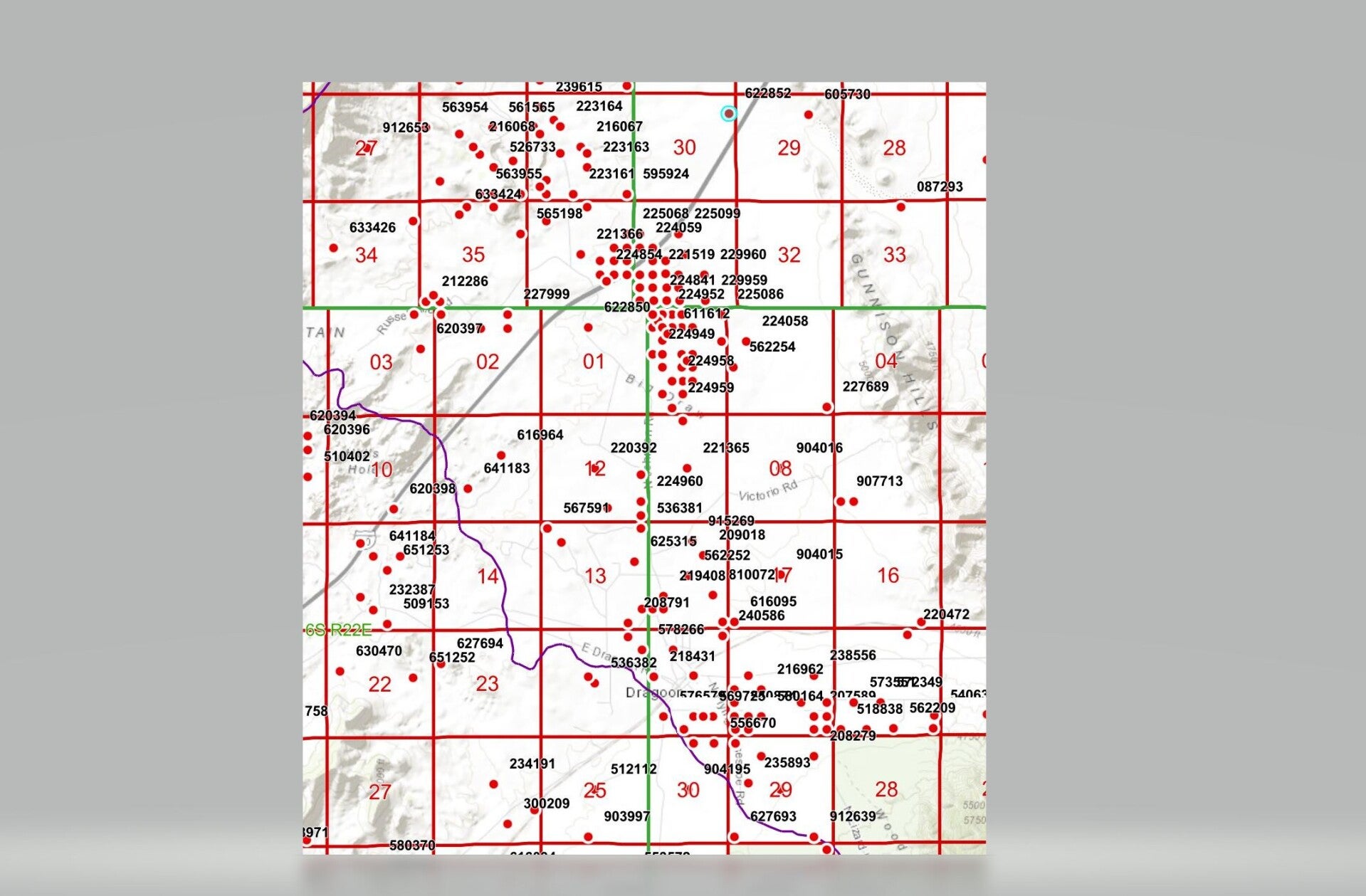
Dragoon area drilling registry map
The image to the left shows all the wells in the Dragoon area in the State of Arizona's well registry database. The red dot in the top center that has a blue circle around it is the mines contaminated water well.
The mass of red dots in the center basically following Johnson road is all the confirmation core samples drilled over the years that the mine company has used to verify the ore presence and concentrations. Typical mining practice.
The mine expansion references 121 more core drilling. Those will be located at the Strong & Harris copper deposit and will be located at the generally at the border of sections 29 and 30 of this map.
Each red dot is represents a hole drilled in the earth. They are not literal illustrations but representative. But this gives one the idea of how many holes have been drilled in Dragoon Pass.
The image to the left is from Arizona Groundwater Explorer found here: https://rconnect.usgs.gov/az-agex/
How does groundwater recharge?
Groundwater levels can recharge meaning that excess rainwater that is given enough time to soak in instead of run off, slowly percolates down into the groundwater.
When having any discussion about groundwater, percolation or recharge needs to be a part of the discussion. In the WGB in general, the water is being used much faster than its replaced. We are all familiar with what is going on as its regularly in the news.
But that same recharge or percolation is also a pathway for contamination. Rainwater that gets contaminated (or other surface water sources like faulty heap leap beds or a leaking acid pipe, leachate, etc,) as it soaks into the earth can carry contaminants deep into our groundwater.
This is one more reason why clean surface water matters!